Imagery processing:
intro to the assignment
GIS/MEA 584:
Mapping and Analysis Using UAS
Justyna Jeziorska
Center for Geospatial Analytics
North Carolina State University
Possible issues
Processing data from UAS can be challenging.
Sources for problems in the processing include:
- Data specific issues caused by:
- bad weather,
- failure of hardware (UAS or sensor),
- wrongly chosen sensor or wrong settings
- not enough information about image localization
- challenging terrain,
- bad flight planning
Possible issues
- Software specific issues caused by:
- incopability between UAS and software (like file extensions)
- memory problems or lack of computational power
- limitation of the software algorithms
Possible issues: bad weather
- Strong wing causes movement of the UAS (especially fixed wing) and the imagery can be very oblique
- Fog, drizzle or snow can limit the visibility and result in low quality images
- Direct sunshine can produce cast shadows that will interfere with processing
Solution
- None. Repeat the survey in better weather
Possible issues: failure of hardware
- UAS can crash
- Camera can not be taking photos (due to battery filure, interrupted connection with UAS...)
- IMU can stop logging the pictures
Solution
- Usually - none. Repeat the survey.
- Unless you are extremely lucky and UAS crashed after acquiring data you needed and you will be able to retrieve it.
- Or the camera stopped working just for a while and its not so significant to your data because you still have sufficient overlap without missing pictures
- If only log is missing - see next slide
Possible issues: not enough information about image localization
- It is possible to process data based on the geotags provided by flight log or EXIF data, but:
- geotag contains image location, not the location of the object depicted on photo
- It is therefore not possible to properly georeference the model without additional information
- without any information about imagery localization it is not possible to georeference or scale the outputs
- (you can produce not georeferenced 3D model or use scale bars for scaling the model)
Possible issues: not enough information about image localization
Solution
- Use GCPs Place targets and include them in processing - more info how to process data with GCPs in Agisoft Photoscan in next slides
- Use RTK/PPK equipped UAS - more info here
Placing markers
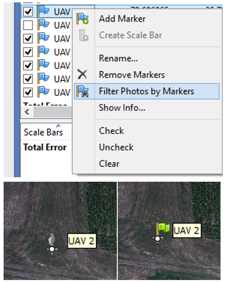
- Click 'Filter Photos by Markers';
- Open an image by double clicking the thumbnail - the GCP will appear as a grey icon;
- Drag the marker to the correct measurement position;
- the marker will appear as a green flag, meaning it is enabled and will be used for further processing.
Optimize Camera Alignment
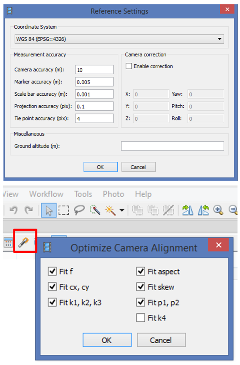
- Set the marker coordinates for optimization (check markers /uncheck cameras);
- Click Settings toolbar button on the Reference pane and set the coordinate system;
- Specify the assumed accuracy of GCP measurements and marker projections on the source photos
- click 'Optimize Camera Alignment'.
Possible issues: challenging terrain
- Homogenous surfaces cannot be processed by SfM algorithms
- Large water areas cannot be processed either (still water is too homogenous and waves move)
- Moving objects can be depicted on multiple photos
Solution
- Avoid large water areas or mask them
- Avoid large moving objects or mask them
- (great tutorial on how to work with masks in Agisoft Photoscan)
- Aviod homogenous surfaces or set GCPs (or other objects) on them
Possible issues: lack of memory
Agisoft Photoscan memory requirements
Aligning Photos
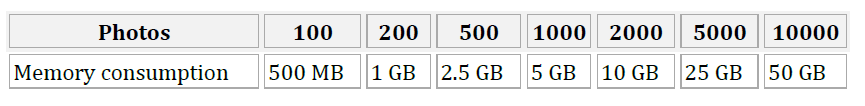
Building Model (Height-field mode)
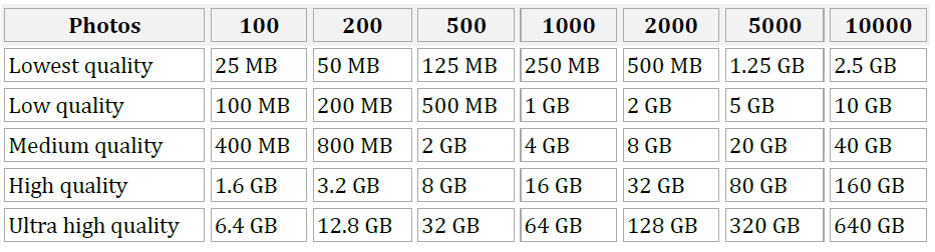
Possible issues: lack of memory
Agisoft Photoscan memory requirements
Building Model (Arbitrary mode)
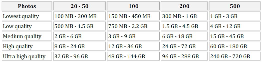
Decimating Model

Possible issues: log file
- Agisoft Photoscan works with raw text files.
Trimble uses its own file formats that need to be converted in order to use it in another software
- If a project file (.gwt extension) is available, the text file can be exported from Trimble Access Aerial Imaging software
Solution
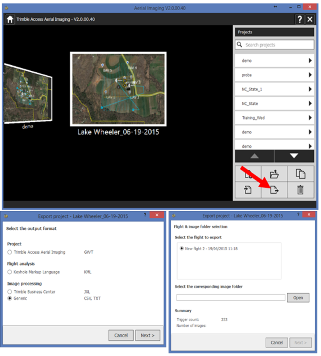
- if only .jxl is available use script by Vaclav Petras
Possible issues:
... are endless