UAS and Lidar Data: Comparison, Fusion, and Analysis
Center for Geospatial Analytics at North Carolina State University
Point clouds from lidar

- The measured variable is the time of flight of each pulse
- Georeferencing from the platform position (GNSS) and orientation (IMU), fused in the INS
- Each (x, y, z) comes from range, position, and attitude; ground control serves only as a check
Point clouds from SfM

- The measured variable is reflected light captured as overlapping images
- Georeferencing from GCPs, or from the camera positions when the UAS carries RTK or PPK GNSS
- Each (x, y, z) is reconstructed from matched image features
Identifying distortions from processing
Difference map: one surface subtracted from the other cell by cell, r.mapcalc; the pattern tells you whether you are looking at error, distortion, or real change

Lidar DSM minus Agisoft DSM

Lidar DSM minus Pix4D DSM
Identifying changes in topography

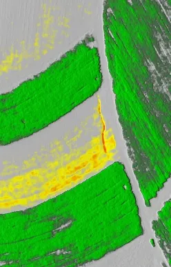

- Vegetation growth or removal: the crop strips, two years apart
- Erosion and deposition: the red gully line
- Custom color rules center the scale on zero so that near-zero differences stay grey
Profiles: fields

- A vertical offset of the whole line is a systematic error
- A local bump is vegetation, or erosion and deposition
Profiles: a building

- High accuracy in all surfaces, less detail in the lidar at the roof edges
- Negligible systematic error between lidar and UAS
Profiles: a road

- Roads and parking lots are easy to find and do not grow
- Lidar and UAS SfM agree within 4 cm here, with a mean offset under 1 cm
Updating a lidar DEM by patching
Patching: filling the cells of one raster with another where the first has data, r.patch; the first input wins wherever it is not null


A UAS DEM patched into a lidar DEM, elevation and shaded relief (images by Brendan Harmon)
Edge between the patched DEMs

- A step of a few centimeters at the seam, and a change of texture
- Water flow follows the step: an artificial channel along the edge
Smooth fusion
Smooth fusion: a weighted average of the two surfaces across an overlap zone along the edge, the weight going from one surface to the other with the distance from the edge; r.patch.smooth in GRASS

Patched

Fused
Fusion method
A linear combination of the two elevation surfaces \(z_A\) and \(z_B\), weighted by the distance \(d\) to the edge of \(A\) over an overlap of width \(s\):
\[ z_{AB} = w\, z_A + (1 - w)\, z_B \] \[ w = \begin{cases} d / s & 0 \le d < s \\ 1 & d \ge s \end{cases} \]

Influence of the overlap width s
Overlap width: how far into the updated surface the blend reaches; too narrow leaves a visible step, too wide erases detail of the better surface

Fusion with spatially variable overlap
- The width \(s(x, y)\) follows the elevation difference \(\Delta z\) between the two surfaces along the edge
- Wide transition where they disagree, narrow where they agree
- Fine features of both surfaces survive where the difference is small

In GRASS: r.patch.smooth -s input_a=uas_ground input_b=lidar_dem output=fused overlap=overlap transition_angle=1.3 parallel_smoothing=13 (Petrasova et al. 2017)
Overlap width from the elevation difference

Patched and fused lidar and UAS DSMs

Patched

Fused, \(s = 20\) m
Fusing UAS bare ground with the lidar DEM

UAS cells within 0.3 m of the lidar ground, in yellow

Fused bare ground
Spatially variable overlap at Mid Pines

Path sampling

Walkers released over the terrain

Water depth from the walker density
Flow over a UAS mapped field

The crop surface acts as a barrier: water ponds against it instead of flowing through
Flow on a patched versus a fused DEM

Patched: an artificial channel along the seam

Fused: the flow follows the terrain
Assignment example: simple and smooth patching

r.patch

Weighted average, \(s = 20\) m
Assignment example: DSM and bare ground
Smooth patched DSM

Fused bare ground